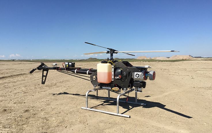
[caption id="attachment_1003727443" align="aligncenter" width="467"]
 RME's proprietary Renegade unmanned aerial vehicle.
[/caption]
CARP, Ont. –
RME Geomatics, a world leading aerial survey services and technology company, announced earlier this month they have delivered a Renegade-M aircraft under the Canadian Federal Government Build in Canada Innovation Program (BCIP). This innovative aircraft will now undergo validation testing through the program in hopes of receiving funding to move this advanced technology from the laboratory to the marketplace.
The newly designed aircraft is a single-rotor helicopter unmanned aerial system (UAS), developed as a magnetically-quiet UAS calibrated through a proprietary procedure with an airframe-fixed commercially available cesium magnetometer. It is capable of flying in manual mode, semi-autonomous with autopilot assistance, or full autonomy for waypoint navigation.
The Renegade-M can operate for a period of up to two hours, depending on the payload, with typical flight speeds of 15 to 25 knots at an altitude of 15 to 300 metres above ground level. The aircraft is also capable of carrying red-green-blue (RGB) camera technology to capture high resolution imagery during a survey, simultaneously with the magnetometer sensor.
The unique design of the airframe on this UAS provides a fixed magnetometer, compared to other rotary wing UAVs that sling the sensor below the airframe. This mitigates safety hazards and decreases the need for high capacity sense and avoid technologies. Additionally, by fixing the magnetometer to the airframe it does away with the challenges of compensating for the dynamic changes in the position and orientation of a slung magnetometer. It is anticipated this will lead to significant gains in data accuracy compared to other platforms.
The Renegade-M has already proven to be an effective tool to gather infrared, hyperspectral, and laser detection and ranging (LiDAR) data. Integrating the magnetometer onto this platform allows for a unique multi-payload capability and therefore the simultaneous production of multiple data sets.
Please visit
www.RMEgeomatics.com to learn more about what the company offers the mineral industry.


Comments