[caption id="attachment_1003730208" align="aligncenter" width="395"]
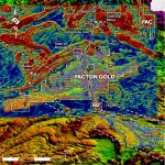 Pacton Gold’s land holdings superimposed on the results of a regional magnetics survey. (Image: Pacton Gold)
[/caption]
ONTARIO –
Pacton Gold of Vancouver recently completed a LIDAR survey over its properties near Red Lake. The light detection and ranging system greatly improved the identification of outcrops and sped up the mapping process. Pacton will use the information in selecting targets for its initial drill program.
Using LIDAR data makes mapping outcrops in a flat, brush-covered area of Northern Ontario much easier. Combining LIDAR and magnetic data generated an unexpected, very strong positive correction between higher elevations and their more erosion resistant rocks and rapid local changes in magnetic intensity, said Pacton.
The company says the new LIDAR data confirms the structural details of the 50-km-long Madsen-Dixie fault corridor. The 7-km-wide corridor passes through the western portion of Pacton’s Red Lake property, including the Carricona-Boyden area where mapping is taking place. The Carricona-Boyden area is to be the first drilled when exploration permits are received.
More information and maps are posted at
www.PactonGold.com.


Comments