PhotoSat announced the launch of its new regional hyperspectral exploration targeting (R-HET) product. The company, a global leader in satellite alteration mineral mapping solutions, will provide mineral exploration companies worldwide with tools to detect more alteration minerals with greater accuracy and discover previously missed opportunities.
PhotoSat provides satellite-based mapping and analysis solutions for mineral exploration, resource development, and mine engineering. The company supports exploration and development projects in over 75 countries.
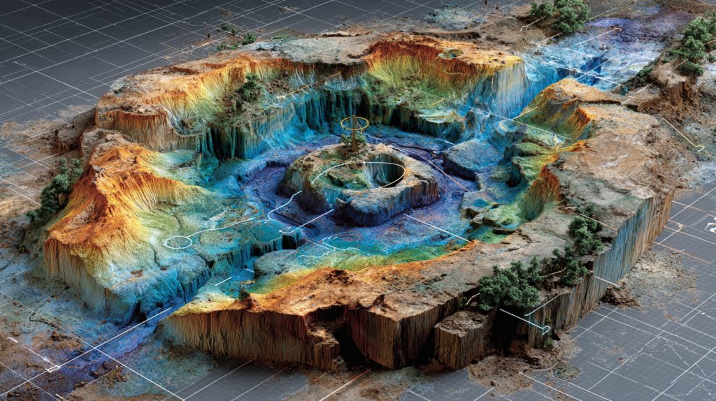
R-HET uses next-generation hyperspectral satellite systems and PhotoSat's proprietary deep-learning algorithms to deliver high-confidence, regional-scale mineral mapping with unprecedented spectral detail. This solution evolves from traditional multispectral approaches, allowing exploration teams to identify more alteration minerals, detect subtle mineralogical variations, and uncover previously overlooked exploration targets from space.
"This innovative technology represents a significant leap forward in our ability to gather and analyze data with unparalleled precision. Having spent years in mineral exploration as a geophysicist, I understand the crucial importance of high-quality data for the success of any project," Gerry Mitchell, former CEO and founder of PhotoSat, stated.
He added: "Our hyperspectral capabilities will empower our clients to make more informed decisions faster than ever before. I believe this product will redefine the standards of excellence in the industry, and I can't wait to see the impact it will have on our clients' exploration efforts."
The R-HET solution enables exploration teams to identify more than twice the number of alteration minerals previously detectable through multispectral data. It can differentiate mineral compositions and crystallinities, detect multiple minerals within the same pixel, map relative mineral abundances, and reduce early-stage exploration costs.
PhotoSat recently completed a case study demonstrating R-HET's capabilities over the Cerro Casale and Caspiche region in the southern Maricunga Volcanic Belt. The study successfully mapped additional key alteration minerals and mineral assemblages not confidently detectable with multispectral datasets.
The company is also developing property-scale hyperspectral exploration targeting (P-HET), scheduled for release in 2026. P-HET will apply PhotoSat's hyperspectral deep-learning models to higher-resolution datasets for detailed mineral identification at the property scale.
"Exploration teams need accurate, data-rich inputs to make confident decisions. Our regional hyperspectral exploration targeting solutions delivers the clarity and depth required to minimize uncertainty, reduce field costs, and accelerate discoveries," Veronique Nell, vice-president of product and solutions, said.
For more information or to request the full case study, visit photosat.ca/hyperspectral-analysis
Comments