The future of mining requires drones: A new way to inspect, survey and map
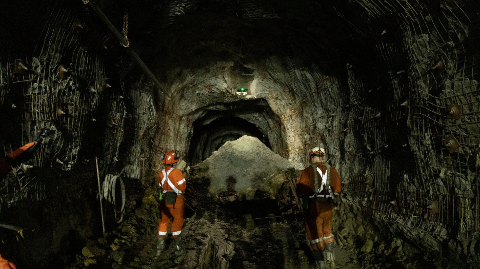
Underground surveys are necessary at nearly every stage of a mine’s life — from initial excavations to assessing blasts, responding to unexpected scenarios and planning backfill for caverns. The way mines conduct these surveys is ready for change. Drone-based inspection is not the technology of the future; it is a necessity for today’s fast-paced digital world. Traditional inspection methods can be slow and costly, requiring a full team of workers and an entire shift to complete a single ore pass inspection. Despite this time and effort, traditional methods often produce incomplete data with shadowing and low coverage. Organizations are looking to digitally transform their industrial processes while cutting costs and improving safety for workers.
Digitalize your mine to transform ways of working
The best advice for any mine operator is to begin the digitalization process now to make it even easier in the future. In just a few flights, you can have a full digital model of your mine, which can then be tracked over time to evaluate changes and allows teams to make highly educated decisions. Drones eliminate the need to send humans into hazardous environments, mapping beyond human access to provide both live video and photos, as well as a point cloud map of the entire space. Terrestrial scanning is nothing new to the mining industry, but the time and physical limitations of these methods leave much to be desired.
Mines are an always changing environment, where places originally deemed safe could change in an instant. Some robotics methods, like using rovers, are still risky since they contact the walls and ground, which can cause disruptions and potentially dislodging materials. They also face obstacles that they simply cannot get around. What is an alternative that keeps humans away but has limited disruption of the structure? A drone can do a reconnaissance flight before human entry to give an accurate picture of the environment within these spaces. They fit in openings as small as 50 by 50 cm, easily maneuvering around caved-in areas, machinery and even beyond line of sight.
In addition to eliminating the risk of disturbing hazardous environments, drones can conduct inspections up to 10 times faster than traditional scanners. This time savings translates directly into increased productivity. Reduced downtime in parts of the mine prevents costly operational delays. Inspectors and engineers gain the time needed to make educated decisions quickly, fixing small issues before they become major problems. Ultimately, last-minute inspections bring peace of mind to the entire facility since they no longer require hours-long shutdowns or lengthy setup times.
What data are confined-space drones capturing underground?
Confined-space drones perform visual inspections, and some even carry onboard LiDAR (Light Detection and Ranging). Give your engineers and inspectors a live visual feed of the space and take photos of points of interest that you can refer to later. If there is a LiDAR on board, the team can then georeference the mapping and locate the exact coordinates of the issue or defect. The lack of GPS signal underground can obviously pose a problem for some tools, but for drones created for GPS-denied environments, they have the ability to use targets to ensure accurate georeferencing, because manufacturers know how critical it is for mines to have precise location measurements when making decisions, whether it is progress mapping or ore inspections.
AI and autonomy have become buzzwords across all industries, but when it comes to drones and robotics it has some tangible abilities that can make any inspection easier. Some drones can autonomously repeat inspections you have mapped out for them. Others can return to the controller when it loses signal or if you need to quickly recall the unit. These features allow you to send a drone into a potentially hazardous environment while mitigating the risk of losing the unit in the process. This gives pilots more confidence to complete their missions and push the drones to access even more.
Post-processing
The initial visual and LiDAR information is important for those inspections where you need immediate information. But the data does not stop there. Visual data creates important historical files to reference back to over time with regular flights. They can check corrosion over time on machinery, like crushers and ball mills. The LiDAR data turns this up a notch, allowing teams to truly monitor what is happening in the mine over time. They can compare scans of stopes, stockpiles, volumes and old workings, monitoring if there have been any unexpected changes. This type of data is invaluable, especially having it at your fingertips and sharing across teams.
The level of density and accuracy depends on the type of LiDAR, with higher quality ones allowing for incredibly in-depth analysis. The more your site is equipped with, the more they can do. Taking these point cloud maps and exporting to software such as Mapteck and FARO Connect allows you to combine the drone data with the other tools you are using on site. Through these models you can visualize the precise location of defects, especially in hard-to-reach areas or use the models to do stockpile volume calculations.
An investment for the future
Drones in a mine may sound like something out of a sci-fi movie, but they are being used by some of the biggest players in the mining industry. Flyability, a confined-space drone company based in Switzerland, was a pioneer in this space and has proven over the last 12 years that drones are essential tools in mapping and surveying. From gold mines in South Africa and Australia to iron ore mines in Sweden, you can find their confined-space drones on site. Drones are now an established part of mine inspections and are fully integrated into the processes at these plants saving them time and money with data that will only help accelerate these savings with time. It is time to invest in your future and bring drones on site.
Related Posts
The critical minerals race is becoming a race for talent
October 16, 2026
The critical minerals race is becoming a race for talent
The lifesavers keeping modern mining moving
October 16, 2026
The lifesavers keeping modern mining moving
Beyond the mine: The multidisciplinary approach shaping Eastern Canada’s mining future
Digging deep: how mining companies need to address community safety internally and externally
Sponsored forum video: Resolute targets first gold at Doropo in 2028
October 15, 2026
Comments