FRANCE – The DroneBox technology is scalable, patented, and designed to equip both plane and multi-rotor unmanned aerial systems, as well as terrestrial photogrammetric and bathymetric unmanned vehicle systems (UVS).
[caption id="attachment_1003715638" align="alignleft" width="193"]
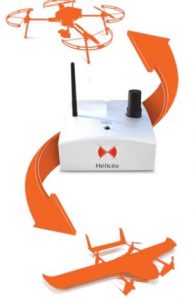 The Heliceo DroneBox for terrestrial or aquatic applications.
[/caption]
This solution is a genuine technological kernel, concentrating 70% of the drone's value. By investing in the DroneBox, professionals gain access to
Heliceo’s seven measurement solutions at a reduced price.
Solutions are available to suit both plane and multi-rotor drones. GNSS RTK boards, autopilot, telemetry, archiving, communication, flight controller and avionics: the DroneBox RTK is a real technological concentrate, capable of detecting a 2-euro coin at a flying height of 150 metres.
The box is adaptable and can equip:
- Plane drones, with a wingspan of 1.5 to 3.5 metres, to survey up to 15 km² (flying endurance increased by 400% in comparison to multi-rotor drones). The Heliceo’s planes are capable of vertical take-off and landing (VTOL).
- Multi-rotor drones, designed to cover small and medium areas of less than 1.5 km². Their static flights perform measurement of cubic volumes, intervention in limited space areas, indoor topographic studies, etc.
The box is equipped with 2 GNSS systems (for navigation and for Trimble RTK measurements) and with a 24-million-pixels camera, optimized by a calibration process developed by Heliceo to correct optical aberrations of the lens.
Each acquired image is thus recorded with its latitude, longitude and altitude (XYZ), allowing geo-referencing to provide, at final, 2-D scaled maps or 3-D digital terrain models (DTM).
"The DroneBox is one of the most accurate products on the market. Road, water body, terrain … it is capable of surveying absolutely everything. It's a flying measurement tool, the 'brain' of the drone. Robotic and auto piloted, using a flight plan recorded in the DroneBox, our drones are totally automatic and allow simplification and safeguarding of piloting," explains Jean-François Baudet, CEO of Heliceo.
The DroneBox is the most cost-effective solution on the market for aerial, terrestrial and aquatic surveying work. It allows professionals to increase their productivity as well as their mission potential. In the future, it will equip tools fitted with LiDAR-type laser sensors and will be usable from moving vehicles.
Contact Guillaume Schavann, marketing manager by phone ( +33 (0) 253 591 235) or email (
guillaume.schavann@heliceo.fr). Or visit
www.Heliceo.com.

Comments