Subsurface intelligence empowers mineral exploration companies to drill less and discover more
And to do it faster, with less environmental impact
At a time when a looming multi-trillion-dollar supply gap in critical metals is putting the mining industry in the spotlight, there is an immense pressure on mining companies to deliver outputs quickly with less cost, risk, and environmental impact than ever before. It begins with exploration activities to determine if there are minerals underground in a target area. The underlying challenge for explorers is never knowing for certain what lies in the subsurface. Miners may extract and analyze data from dozens, hundreds, or even thousands of drill holes, interpolating what may exist between those geological biopsies. Even with all those holes, they still do not know for sure, yet enormous investment and operational decisions are based on that fractional information about what might be there.
This geological uncertainty impedes growth, drives costs, and slows time to market. Better subsurface intelligence can close the gap on that uncertainty, reducing it dramatically and providing the tools to quantify what is left, giving mineral exploration and mining companies greater confidence to move earlier, faster, and with less downstream risk. In turn, this helps them get the critical metals the world needs to market more quickly, safely, and profitably.
Subatomic particles reveal subsurface geological features more efficiently than drilling
Vancouver-based Ideon Technologies uses naturally occurring energy from supernova explosions in space, in the form of subatomic particles called “muons,” to image deep beneath the Earth’s surface. As the world’s pioneer in the development and application of cosmic-ray muon tomography, Ideon has developed the “REVEAL” subsurface intelligence platform, comprising an advanced suite of proprietary data-generation hardware, software, AI-powered services, and multi-physics fusion that together unlock the exponential power of integrated spatial data. The REVEAL for Exploration solution helps mining companies map and characterize mineral deposits with precision and confidence, allowing them to precisely target and delineate subsurface features, at depth, on remote greenfield sites, or in the complex operational environment of active brownfield mine sites. It delivers a high-volume, high-resolution, high-velocity Earth model that can improve the accuracy of density mapping and drill targeting, expedite geological modelling, and directly inform mine planning.
This foundational technology — muon tomography — is the only straight-line subsurface imaging technology available today, delivering the highest available resolution along with precise anomaly location information. It uses a passive and free energy source (from space), offers the ability to image in noisy or conductive environments (where other techniques do not), providing insights from depths that other techniques cannot, and captures data continuously, thus improving imaging results over the course of a survey.
By measuring muon activity through detectors positioned in a few select boreholes, the average density in the overburden within a wide field of view above each detector can be determined. Each detector produces a radiographic (X-ray-like) image of the rock mass above it, with significant geological features standing out clearly because of their density contrast with the surrounding rock. By utilizing multiple detectors with different views of the subsurface, the density of a volume of rock can be estimated through triangulation of the intensity of muons recorded at different detector locations. The muon data can be inverted into a block model that provides a high-resolution 3D estimate of subsurface density that tightly constrains the shape and size of any geological features imaged. This unique data source, combined with advanced processing algorithms and multi-data-set analysis, gives mining exploration companies a comprehensive set of subsurface intelligence that they have never had access to before.
Working in partnership with Vancouver-based Fireweed Metals (part of the Lundin Group), we demonstrated how the REVEAL for Exploration solution can significantly reduce the drilling costs associated with mineralization validation.
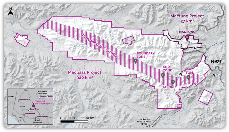
Case study: Fireweed Metals’ Macmillan Pass (Macpass) District
Located in eastern Yukon Territory about 400 km from Whitehorse, Fireweed Metals’ Macpass project lies within the traditional territories of the Kaska Dena Nation and the First Nation of Na-cho Nyäk Dun. It hosts several large zinc-lead-silver deposits within the 940 km2 property, which is recognized as one of the world’s largest undeveloped primary zinc districts. It also has the potential to be a significant source of by-product strategic elements like gallium and germanium.
Ideon worked with Fireweed to deploy the REVEAL for Exploration solution at Macpass in the fall of 2024 with a goal to identify and map new targets for drill-testing during Fireweed’s summer 2025 exploration campaign. The very high density of high-grade massive sulfide bodies observed at Macpass makes these kinds of targets particularly well-suited to detection using muon tomography. Beyond generating new targets, Ideon was able to greatly improve characterization of the existing mineralization structure, address key geological hypotheses, and identify reasonable extensions adjacent to the known mineralization structures.
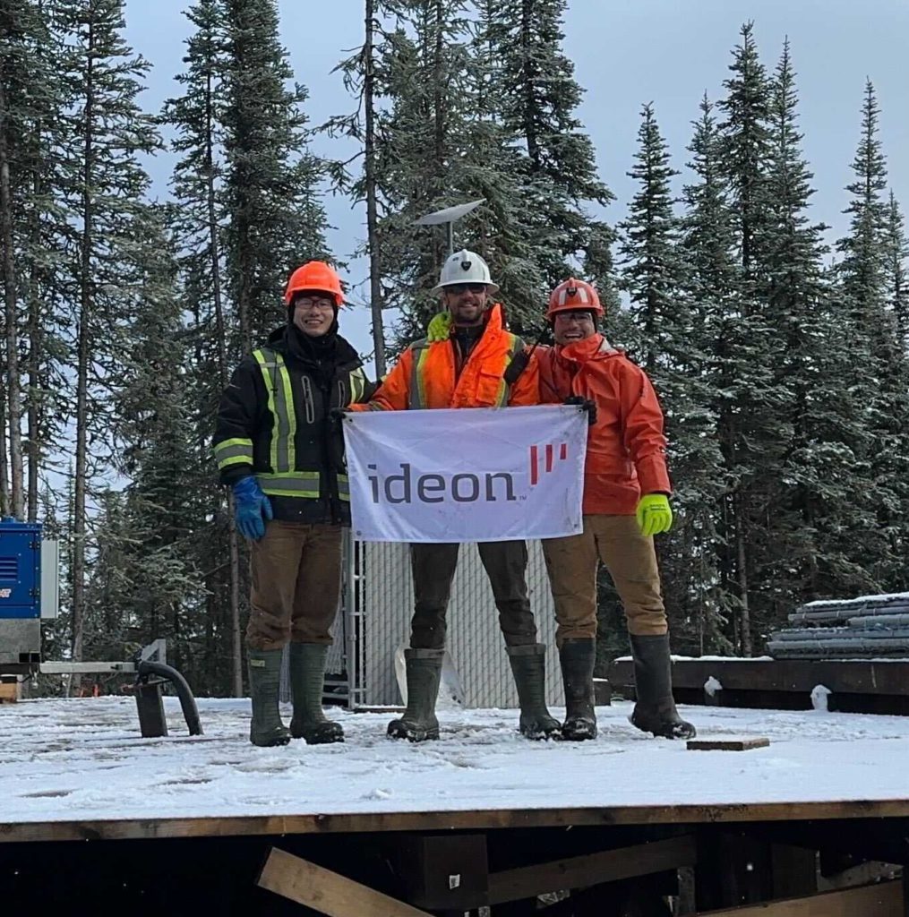
In late September 2024, Ideon positioned multiple muon sensors in arrays down three drillholes across one km strike length, down to 550 metres depth, covering 2.5 km2 in the Boundary Zone of Macpass just before camp closed for the season. To prevent the possibility of hole collapse (a known challenge in this region), the sensors were deployed inside the metal drill rods, which were left in place for the imaging program. The sensors mapped density at metre-scale resolution over a volume of 600 million m3 throughout the harsh Yukon winter. An autonomous power solution kept the sensors imaging over the season, and data was transferred regularly via satellite connection from site to the Ideon labs in for analysis.
Actionable geological insights delivered well ahead of schedule
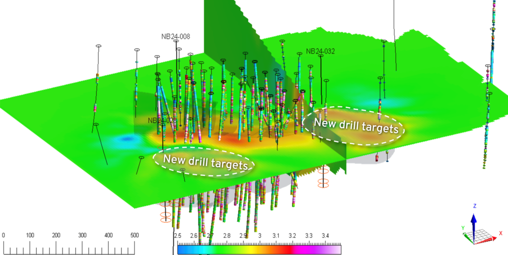
After four months of passive imaging, the muon survey independently detected and modelled volumes of high density that closely resembled the orientations and spatial constraints of the deposit defined through prior drilling by Fireweed. The subsurface model, generated blindly without any constraining information from the site, using data acquired from muon sensors with large fields of view deployed in just three drillholes, showed excellent agreement with mineralization data extracted from 50 holes previously drilled in the area, significantly enhancing the understanding of structural trends in the subsurface geology.
Not only did these results validate key geological hypotheses about the site and confirm mineralization trends, but they also identified three new advanced drill targets outside of the mineral resource exhibiting anomalous estimated density, which will inform the summer of 2025 exploration campaign. Beyond establishing new targets for exploration in areas that currently have no drilling at all, the Fireweed team used the muon data to develop a robust 3D model of the known mineralized area that gives them greater confidence in the continuity between drill interceptions (50 to 100 metres apart). It helped them validate the tonnage of the deposit and compare it to what they saw in the mineral resource, while also validating mineralization structures (stratiform nature of the mineralization and geology, with interspersed low- and high-density bands) and confirming a geological hypothesis that a fault truncated the massive sulfide zone. The new robust density model has given the Fireweed team confidence that they have estimated the resource as correctly and as accurately as they could.
Muli-physics analysis yields “1 + 1 = 3” impact
Over the years, Fireweed had acquired a rich ground gravity data set across the district. Once the muon imaging had been analyzed, the team opted to combine this gravity data and the muon data into a single 3D inversion to assist in targeting. Areas of anomalous density in both surveys corroborate very well and generated an improved model over the inversion from either dataset alone. The gravity data is a surface measurement and thus more sensitive to density anomalies closer to the surface, providing regional understanding of the bulk properties of the subsurface. The muon data, which images upwards from beneath the target zone, delivers much better sensitivity and higher resolution at depth, allowing for the more effective detection of density anomalies than using gravity alone.
In the summer of 2025, Fireweed will drill-test new targets. Having seen the outcomes at Boundary Zone, they also will be using muon tomography and gravity over a much larger area in the upcoming exploration season.
Leveraging technology to drill less and discover more and faster
By mapping large volumes of the subsurface over the off-season, this technology can help greenfield explorers reduce the time to fully explore an area by more than 50%, quickly building a macro view of a large volume of earth in an exploration zone. As a result, the overall amount of drilling to confidently map, delineate, and understand mineralization can be reduced up to 90%, allowing companies to then focus remaining drilling activity on validating targets rather than trying to discover them. They can identify new targets, understand their parameters (mass, 3D geometry, and size), and narrow step-out drilling plans. Ultimately, this allows them to gain crucial confidence earlier on, achieve more with limited drilling resources, reduce site disruption, and avoid bureaucratic hurdles that slow progress.
The REVEAL for Exploration solution is equally productive for near-mine exploration on active brownfield sites, delivering the high-resolution imaging needed to precisely delineate subsurface features, at depth, and in complex operational environments. It can identify subtle differences in subsurface features that other technologies completely miss and can be used to remotely identify subsurface structures or voids that could mitigate potentially unsafe situations for personnel or equipment. No other remote sensing technology can deliver this powerful combination, which can unlock millions in annual value per mine and allow miners to confidently move on without fear of having missed anything between widely spaced drillholes.
The technology is de-risking critical metal exploration and mining processes by quantifying and reducing geological uncertainty in an environment that has traditionally been very uncertain. 
Gary Agnew is CEO and co-Founder of Ideon Technologies.
Comments