[caption id="attachment_1003731210" align="alignnone" width="550"]
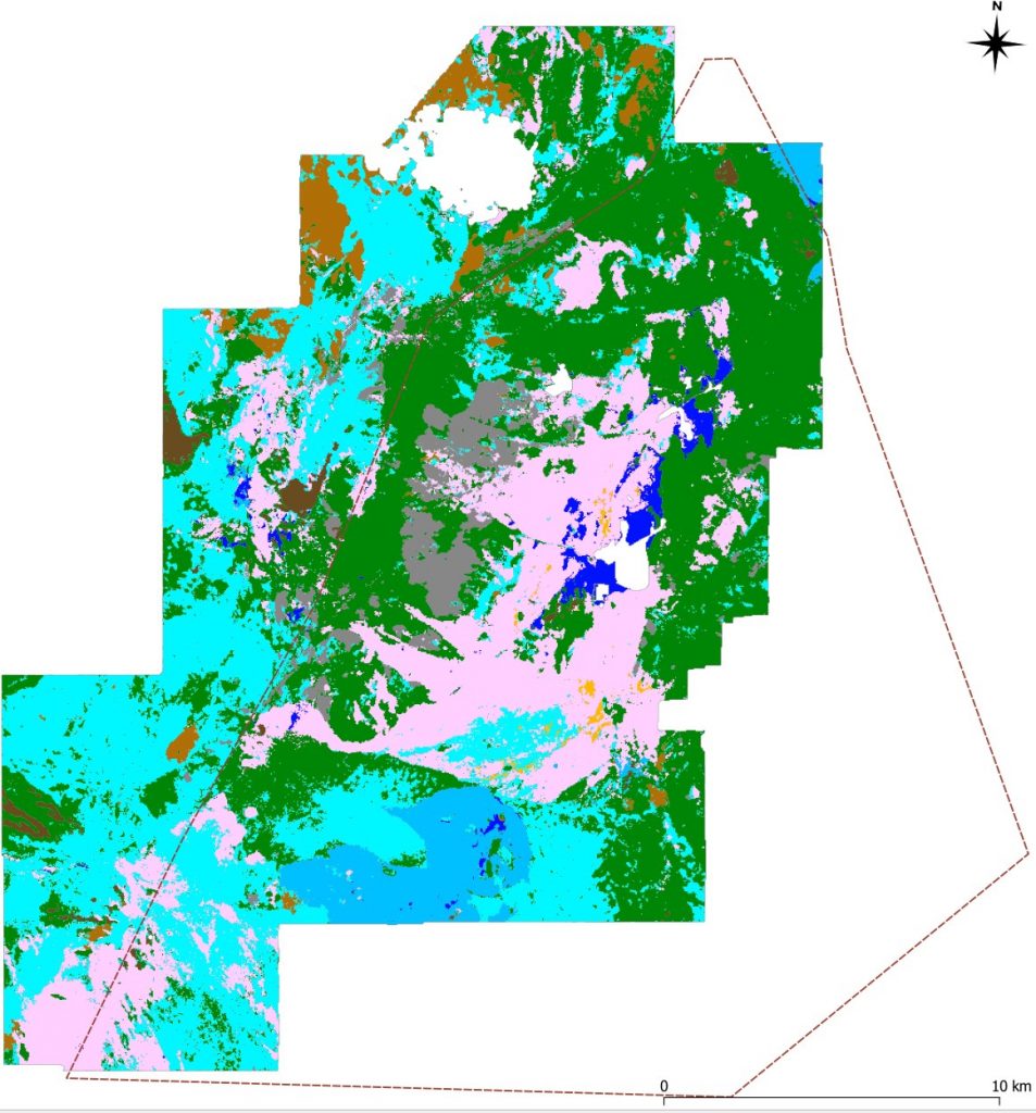 Machine learning produced geological map. Credit: GoldSpot Technologies
[/caption]
TORONTO – GoldSpot Discoveries and Yamana Gold have created a lithological map for the El Penon gold mine site, in northern Chile, using machine learning.
GoldSpot says its proprietary technology uses deep learning artificial intelligence (AI) models to create predictive lithological maps and that its technique speeds up exploration targeting and pattern discovery.
“GoldSpot and Yamana Gold recently completed a machine learning collaboration in the area surrounding the El Penon mine site using extensive, multidisciplinary, geological, geophysical and geochemical datasets,” said Henry Marsden, Yamana's senior vice-president, exploration, in a release. “The study was successful in identifying known mineralized areas in the mine in blind tests and is now playing a significant role in aggressive ongoing exploration efforts. GoldSpot was able to create a predictive lithological map for covered areas that is particularly useful for prioritizing drill targets."
GoldSpot says its technology is especially effective in areas where rock exposure is poor, making visual observations more difficult. Usually lithogical maps are created through a geologist's visual observations, with remote sensing and geophysical data used to fill in the picture with “predictive lithological mapping.”
The simplest type of predictive lithological mapping has been for geologists to simply observe datasets which are printed out and layered on top of one another, GoldSpot notes. This kind of manual pattern recognition may be effective when the geologist has experience in a particular area, GoldSpot says, but it is also a time-consuming and subjective approach.
GoldSpot says its technique is currently being applied at greenfield projects and for brownfields districts where conventional approaches have proven ineffective. The company adds the quality and distribution of input data is critical, and can include drone/satellite remote sensing and geophysical data. The most successful projects have integrated a selection of radiometrics, magnetics, satellite hyperspectral, synthetic aperture radar, and thermal infrared data.
For more information, see www.goldspot.ca.

 Machine learning produced geological map. Credit: GoldSpot Technologies[/caption]
TORONTO – GoldSpot Discoveries and Yamana Gold have created a lithological map for the El Penon gold mine site, in northern Chile, using machine learning.
GoldSpot says its proprietary technology uses deep learning artificial intelligence (AI) models to create predictive lithological maps and that its technique speeds up exploration targeting and pattern discovery.
“GoldSpot and Yamana Gold recently completed a machine learning collaboration in the area surrounding the El Penon mine site using extensive, multidisciplinary, geological, geophysical and geochemical datasets,” said Henry Marsden, Yamana's senior vice-president, exploration, in a release. “The study was successful in identifying known mineralized areas in the mine in blind tests and is now playing a significant role in aggressive ongoing exploration efforts. GoldSpot was able to create a predictive lithological map for covered areas that is particularly useful for prioritizing drill targets."
GoldSpot says its technology is especially effective in areas where rock exposure is poor, making visual observations more difficult. Usually lithogical maps are created through a geologist's visual observations, with remote sensing and geophysical data used to fill in the picture with “predictive lithological mapping.”
The simplest type of predictive lithological mapping has been for geologists to simply observe datasets which are printed out and layered on top of one another, GoldSpot notes. This kind of manual pattern recognition may be effective when the geologist has experience in a particular area, GoldSpot says, but it is also a time-consuming and subjective approach.
GoldSpot says its technique is currently being applied at greenfield projects and for brownfields districts where conventional approaches have proven ineffective. The company adds the quality and distribution of input data is critical, and can include drone/satellite remote sensing and geophysical data. The most successful projects have integrated a selection of radiometrics, magnetics, satellite hyperspectral, synthetic aperture radar, and thermal infrared data.
For more information, see www.goldspot.ca.
Comments