[caption id="attachment_1003730670" align="aligncenter" width="470"]
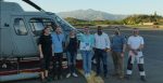 The SkyTEM team has proudly flown 1 million km gathering top quality data for its customers.
[/caption]
TORONTO – In the course of providing airborne geophysical surveys,
SkyTEM Surveys has flow and mapped 1 million km. That’s equivalent to almost 25 trips around the world and all of it mapping with helicopters on all seven continents, safely and without incident or accident.
In 2004 SkyTEM launched breakthrough airborne geophysical technology that delivers highly accurate images of the earth from the very near surface to depth. Recognition of the technology grew quickly as scientists and resource explorers globally turned to SkyTEM for solutions to a wide range of subsurface visualization challenges. Today SkyTEM proudly announces achievement of a major milestone: The collection and delivery of over 1 million km of airborne electromagnetic data.
SkyTEM reached this point by attracting highly qualified and dedicated people to work in a culture of innovation and continuous improvement – and the company engineered the best airborne geophysical mapping systems possible. The result is unparalleled technology available in a choice of systems suited for a wide variety of exploration objectives. As the success stories have spread, SkyTEM has also became recognized for their professionalism and focus on client needs.
Today SkyTEM is engaged by government agencies, resource exploration companies and environmental and geotechnical engineering companies worldwide. The company is transparent in what they do, they show their work. Clients trust the earth data they receive and confidently rely on it to make critical decisions.
The 1-million-km journey doesn’t stop here - this milestone is only the beginning and SkyTEM is excited to continue advancing the technology, its influence and its solutions.
“Thank you for relying on SkyTEM to satisfy your mapping requirements and we look forward to serving you in the months and years to come. We couldn’t have done it without our employees, customers and partners. To all of you, thank you.” Dr. Flemming Effersø, CEO, SkyTEM Surveys ApS.
SkyTEM is the leader in innovative airborne geophysical survey services. We deliver advanced data collection systems engineered to meet the high data density and high data quality requirements of earth scientists for a wide range of subsurface studies. SkyTEM pioneered calibrated dual moment technology for mapping the very near surface to great depths, concurrently, economically and consistently, with rapid acquisition and delivery speeds. The best solution for high quality data, SkyTEM deliverables are robust and dependable enabling explorationists to build accurate geological models with confidence.
Explore
www.SkyTEM.com.


Comments