Decoding the planet: The future of the subsurface
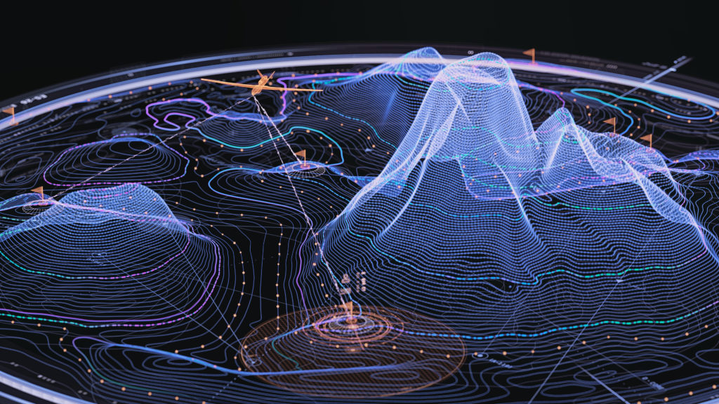
Tactical drone mission interface displaying a 3D topographic mesh with contour lines, orange waypoint flags and connecting paths, presented with icons on dark and light backgrounds for precise target acquisition.
For centuries, humanity has looked to the stars with wonder, mapping distant galaxies and sending probes to the edge of our solar system. Yet, beneath our very feet lies a world that remains largely a mystery. The Earth’s subsurface — vast, complex layers of rock and soil that store our water, energy, and the critical minerals needed for a green future — is surprisingly difficult to navigate.
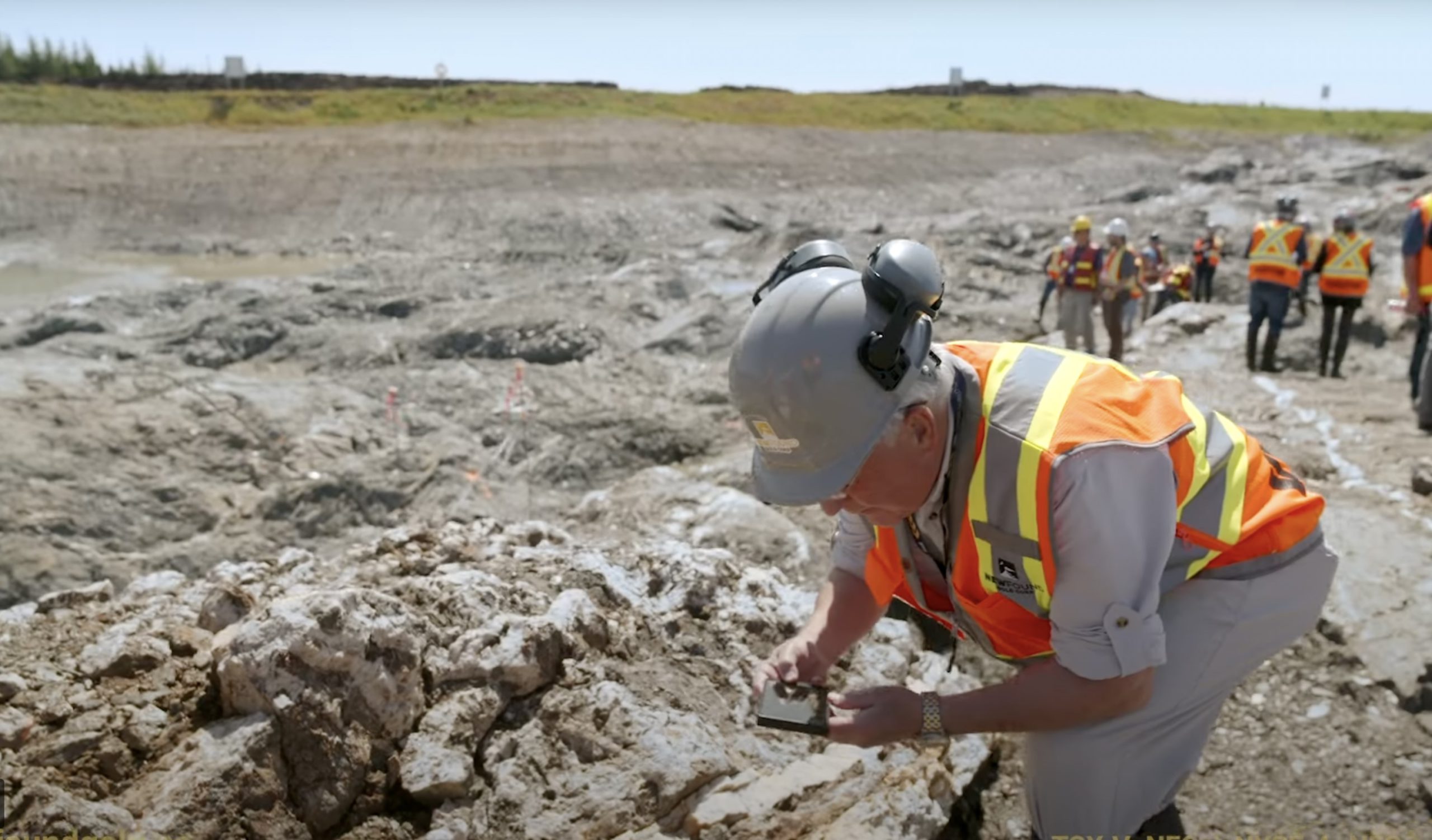
Traditionally, finding these resources has been a game of high-stakes hide-and-seek. Geologists rely on “sparse data” — bits and pieces of information gathered from expensive drill holes, satellite images, and historical records. But as the world’s demand for critical minerals like copper, lithium, and nickel skyrockets, the “old way” of discovery is not enough. The success rate for finding new mineral deposits hovers around 1% or even lower.
This is where artificial intelligence (AI) comes in. By merging the centuries-old science of geology with the innovative power of generative AI, Earth Dynamics has created the world’s first “Geologic Intelligence” platform. This technology is not just an incremental improvement; it is a fundamental shift in how we understand and interact with our planet. We are reimagining the earth to decode it better.
The challenge of the “black box”
To understand why this technology is so revolutionary, we first must understand the problem. The Earth is a messy, unpredictable place. Unlike a factory where every part is accounted for, the subsurface is a “black box.” Geologists use diverse methods of reasoning/logic to understand what they see in one drill hole and then predict what might be happening a mile away.
Furthermore, the industry is drowning in data that it cannot easily use. Over the last century, exploration companies have produced millions of pages of paper reports, hand-drawn maps, and chemical assays. Much of this reality is dealing with “unstructured data;” in other words, mountains of information not organized efficiently. For human teams to manually process and digitize this mountain of historical knowledge would take many years.
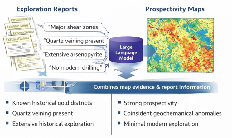
“Geoscience Foundation Models” can be used to close the loop between unstructured geoscience data and geological understanding. These are AI systems trained specifically on the “language” of the Earth. By teaching the AI agent to understand rocks, magnetic fields, and geological structures, it can process information at a scale and speed that was previously impossible.
The four pillars of geologic intelligence
The platform is built on four core technological principles, each designed to solve a specific piece of the geological puzzle: GeoSim, GeoReasoning, GeoVision, and GeoIntegration.
1. GeoSim: The generative simulator
One of the most impressive features of Earth Dynamics’ platform is GeoSim. In many ways, it acts like a “3D Time Machine” for the subsurface. Because it cannot see through miles of solid rock, GeoSim uses generative modeling to create high-fidelity 3D simulations of what the ground looks like.
Crucially, these are not just random drawings. They are geologically and physically plausible models. By simulating different geological scenarios, GeoSim helps exploration teams visualize the “space between the holes,” reducing the guesswork involved in where to drill next.
2. GeoReasoning: The digital archivist
GeoReasoning is the “brain” that tackles the problem of messy, historical data. It uses agentic AI to function as a virtual geoscience assistant. These AI agents can read through decades of old exploration reports, understand the context of the minerals mentioned, and automatically extract the important data points. This process turns “dead data” sitting in dusty archives into “living assets.” GeoReasoning can find patterns across thousands of documents that no human could ever read in a single lifetime, identifying clues that may have been overlooked 60 or 70 years ago.
3. GeoVision: seeing the invisible
Geophysics, the study of the Earth’s physical properties, often involves looking at complex signals generated by geophysics, geochemistry, remote sensing, and other modalities. These signals are frequently “noisy” and difficult to interpret accurately. GeoVision uses advanced computer vision to “see” through this noise. It identifies subtle structural relationships and mineral targets directly from the data.
4. GeoIntegration: The master weaver
The final pillar is GeoIntegration. Geology is a multidisciplinary field; you might have chemical data, magnetic data, satellite imagery, and drill logs all for the same piece of land. Historically, these different “data silos” rarely talked to each other.
GeoIntegration is the glue that binds all these elements together. It provides a unified framework where all data types — from a high-resolution satellite photo to a chemical analysis of a rock chip — are combined into a single, cohesive “digital twin” of the subsurface. This ensures that every decision made by an exploration team is based on the full picture, rather than just one piece of the puzzle.
A tool for global challenges
While technology itself is fascinating, the real-world application is even more critical. The world is currently in a race to transition to a more sustainable energy future. Building electric vehicles, wind turbines, and solar panels requires an unprecedented number of metals.
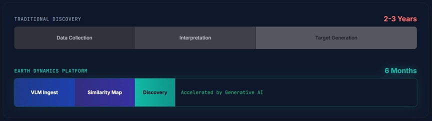
The “easy” mineral deposits, those close to the surface and easy to find, have largely been discovered. The future of mining lies in finding the “blind” or “under discovered” deposits located deep beneath the surface of the earth. Earth Dynamics’ ability to compress the exploration timeline — potentially turning a multi-year search into a project within a few months — is essential if we are to meet the global demand for critical minerals.
Collaboration, not replacement
A common fear when discussing AI is that it will replace human workers. However, the philosophy behind this technology is one of “Expert Intelligence.” The platform is designed to be a collaborator, not a replacement.
By taking over the heavy lifting of data processing, 3D modeling, and archival research, the AI allows geologists to focus on what they do best: applying their deep experience and intuition to high-level decision-making. The AI provides the map and the insights, but the geologist remains the explorer.
A new era of discovery
The technology represents a bridge between two worlds. It takes the physical, tactile science of geology and enhances it with the digital power of generative AI. By decoding the “black box” of the Earth’s subsurface, we are not just finding rocks; we are finding the building blocks of a modern, sustainable society.
As we move forward into an era where resources are harder to find and more essential than ever, “Geologic Intelligence” is positioned to become the standard for how we interact with our planet. To build a better future on the surface, we first have to master the secrets of the world below.
Related Posts
Precision over volume: Surface mining’s new productivity imperative
New Found Gold wins TSX green light
June 29, 2026
New Found Gold wins TSX green light

New Stormlands modelling pushes Frotet to US$3B
June 29, 2026
New Stormlands modelling pushes Frotet to US$3B
Are your mining operations automated? Navigating Canada’s evolving regulatory landscape
The case for a Canadian strategic minerals stockpile
June 26, 2026
Comments