[caption id="attachment_1003743140" align="aligncenter" width="550"]
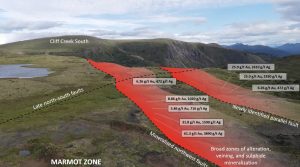 Mineralized zones at Lawyers Credit: Benchmark Metals
[/caption]
Benchmark Metals has announced that its regional exploration efforts across the 140-sq.-km Lawyers gold-silver project in the Golden Horseshoe have defined two new prospective zones – LaLa and Gifford’s Edge.
LaLa, 1.3 km from the Marmot target, returned bedrock grab sample assays of up to 8.22 g/t gold and 897 g/t silver (19.4 g/t gold-equivalent). The high-grade samples from this area were collected along a northwest to southeast trend, which, according to Benchmark, is indicative of strike extensions of the Marmot-area mineralization. In addition, a large portion of the area between LaLa and Marmot is covered, potentially masking the full extent of this emerging trend.
At Gifford’s Edge, 1 km north of the existing Marmot East soil anomaly, rock grab samples returned up to 27.9 g/t gold and 378 g/t silver (32.6 g/t gold-equivalent). This zone includes a 250-metre by 250-metre soil anomaly, with northwest-to-southeast striking mineralized structures.
Benchmark is working to advance these zones to the drill-ready stage for next year’s exploration program.
In addition, drill results are pending for the Marmot and Silver Pond zones. Marmot covers an area of 2 km by 3 km with past grab sample assays of up to 61.3 g/t gold and 3,890 g/t silver (109.9 g/t gold-equivalent). Silver Pond is a 4-sq.-km alteration zone with zonation patters and metal associations indicative of high-sulphidation or porphyry mineralization. A geophysical survey, covering 2.5 sq. km of this area, outlined geophysical anomalies, which appear to coincide with mapped alteration patterns and fault zones.
In addition to these two new discoveries above, Benchmark has completed rock and soil sampling, mapping and geophysics over the Kodah, Round Mountain, Arctic/E-grid, Marmot Lake East, Black Lake alteration corridor and Lawyers Southeast areas.
“The potential of the 20-km Lawyers trend has grown well beyond what was identified by the historic Cheni Mine into an emerging district-scale gold and silver exploration region,” John Williamson, the company’s CEO, said in a release. “As we continue to systematically explore our highly prospective 140-sq.-km land position with comprehensive geological mapping, soil and rock sampling, ground and airborne geophysics, and exploration drilling, we continue to add new zones that share the same characteristics as the resource areas in the heart of the property. We are confident that this will add significant new gold and silver ounces to our forthcoming mineral resource estimate.”
With over 75,000 metres drilled thus far this year across the Cliff Creek, AGB and Dukes Ridge areas, Benchmark expects to complete 90,000 metres to 100,000 metres ahead of a first-quarter resource update.
In 2018, Benchmark released an initial inferred resource for the Cliff Creek North and Dukes Ridge zones at Lawyers: Cliff Creek North features 550,000 inferred tonnes, grading 4.51 g/t gold and 209.15 g/t silver, with an additional 58,000 inferred tonnes at Dukes Ridge, at 4.3 g/t gold and 139.13 g/t silver.
For more information, visit
www.BenchmarkMetals.com.


Comments